After half an hour's strolling, it's relatively simple, with coastal trestles, fun, and small trains, crystal caves. It was winter and the sea was windy, but you could visit it or not. From there you could see the donkey island opposite.
Motianling Review
4 /5203 Reviews


1 / 3


5/5
Motianling
Posted: Feb 28, 2018


4 person liked this
Like
 5/5OutstandingOriginal Text
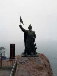
Lianshanguan skyline is a natural barrier on this ancient road. The mountains are steep and majestic. The shrub forest composed of red pine, larch, scorpion, scorpion, scorpion, scorpion, scorpion, scorpion, scorpion, scorpion, scorpion and other trees, with lush branches and greenery. The king of the imperial history of the east of Mingliao, the governor of the imperial history of the imperial history, depicted it with five-word poems, "even the mountains are green and the horses are also able to pass. Related to the condensing of the Han, through the forest and cover the sky", which can be seen as the mountain's top and the geographical weight.
Posted: Aug 31, 20231 5/5OutstandingOriginal Text
Motianling is located in the east of Liaoning, 80 kilometers west of Benxi City south, 50 kilometers from Liaoyang City northwest, is the east-west boundary of Benxi and Liaoyang Mountain, and the north-south is the boundary point of Lianshanguan and Xiamatang and town. The mountain is 969 meters high. Because of the mountain height, it is called the skyline, also called the Dagaoling, Taikaoling or kaoling. In war years, it is a military key place, and in peacetime it has a high tourism development value.
Posted: Aug 31, 20230 5/5OutstandingOriginal Text
Lianshanguan Motianling, located in Lianshanguan Town, Benxi Manchu Autonomous County, south of Dandong Fengcheng, west of Liaoyang Liaoyang County, north of Benxi Nanfen District. The highest altitude is 969 meters, longitude and latitude coordinates: 40°57 ′ north, 123°45 ′ east.
Posted: Aug 31, 20230 5/5Outstanding
Verified Booking
Original TextYesterday, the ropeway at 9:30 in the morning was basically not lined up, only took the North ropeway, the scenery was really good, it was worth sitting.
Posted: May 5, 20240- 5/5Outstanding
Verified Booking
Original TextIt is really convenient to buy a joint ticket, and there are many discounts. It is recommended to consider the family and children who travel! !
Posted: Jul 29, 20230 - 1
- 2
- 3
- 4
- 41
Recommended Attractions at Popular Destinations
Bangkok attraction near me | Tokyo attraction near me | Manila attraction near me | Hong Kong attraction near me | Taipei attraction near me | Seoul attraction near me | Los Angeles attraction near me | New York attraction near me | Shanghai attraction near me | Kuala Lumpur attraction near me | Shenzhen attraction near me | Osaka attraction near me | Singapore attraction near me | London attraction near me | Guangzhou attraction near me | San Francisco attraction near me | Beijing attraction near me | Macau attraction near me | Bali attraction near me | Paris attraction near me | Ho Chi Minh City attraction near me | Orlando attraction near me | Jakarta attraction near me | Chicago attraction near me | Phuket attraction near me | Toronto attraction near me | Fukuoka attraction near me | Istanbul attraction near me | Dallas attraction near me | Chiang Mai attraction near me
Popular Attractions
Hu Xueyan's Former Residence | Stedelijk Museum Zwolle | Chengdu Happy Valley | Plaža poštenja | Layag Hill Peak | Sungtseling | GREEN TURTLE HIGHLAND RESORT | Negeri Diatas Awan Bogor | Tang Paradise | Dafen Oil Painting Village | Disneyland Paris | Degener OPEL Museum (DOM) - Vogelsang IP (NS-Ordensburg) | Chengdu Research Base of Giant Panda Breeding | Sunway Lagoon Theme Park | Momchilovtsi Herb Garden | Multi Treasure Pagoda of Glazed Tiles | Igor Stravinsky Museum | El Arbol Teatro Infantil | Museo Civico Giovanni Marongiu | Rorie Galloway Day Camp | Masjid Miftahul Hidayah | Sa perda sperrada | Shani Temple | Fridegård park | Church of St. George | Salesas Park | Galleria Civica D'arte Contemporanea | Bērzmuižas dzeltenās priedes | Wildlife Museum | Sagrada Familia
Payment Methods
Our Partners
Copyright © 2024 Trip.com Travel Singapore Pte. Ltd. All rights reserved
Site Operator: Trip.com Travel Singapore Pte. Ltd.
Site Operator: Trip.com Travel Singapore Pte. Ltd.