Open park, National Geographic Sign, China's geographical north-south dividing line, permanent park. There are quite a lot of people who get up in the morning to exercise, the old road of the Yellow River and the ancient road of the Huaihe River. The east flow of the river is rising, and the loess is blowing westward. The shore of the old road of the Yellow River is winding.
North-South Geographical Boundary Indication Park Review
4.3 /541 Reviews


1 / 3

5/5
North-South Geographical Boundary Indication Park
Posted: Nov 25, 2020
Like
 4/5ExcellentOriginal Text
So, if you say Yangzhou is not southern, and Yangzhou people are not southerners, they will be unhappy to see Huai'an's north-south boundary park, you need to go out of Beijing-Shanghai Expressway, but it is definitely worth a look.
Posted: May 4, 20233 4/5ExcellentOriginal Text
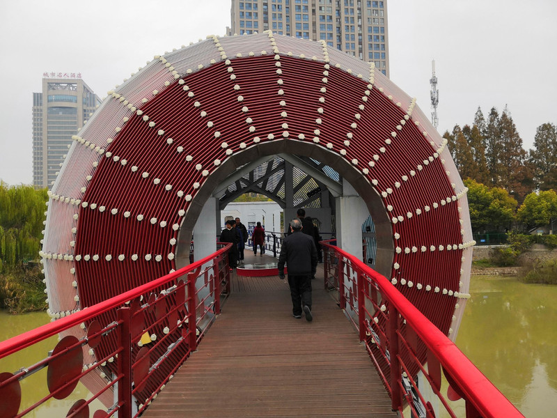
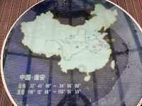
Slowly walk slowly, Jiangsu Huai'an North Boundary Sign Park! ! ! The boundary point is in the big ball in the middle of this bridge. The river in the picture is called the Waste Yellow River. In fact, it is the old road of the Yellow River, which means the ancient Yellow River! !
Posted: Nov 27, 20200- 5/5OutstandingOriginal Text
When the spring was in Jiangnan and Jiangbei, I didn't find a sculpture waiting for precipitation. I asked the locals and said I didn't know. Did it be removed?
Posted: Apr 29, 20232  5/5OutstandingOriginal Text
Huai'an's south and north boundary sign park, you can check in
Posted: May 1, 20230 5/5OutstandingOriginal Text
The north-south dividing line is China's north-south dividing line. Huai'an City, Jiangsu Province, is on the dividing line. It is worth everyone to take a look.
Posted: Sep 15, 20220 3/5AverageOriginal Text
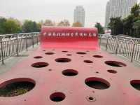
As we all know, the geographical dividing line between the north and the south of China is the Qinling Huaihe River. Huai'an as a node should be very hoping to highlight itself to attract attention, so a new north and south geographical dividing line sign park was built in 2008, and was built the next year. The "Red and Blue Bridge" as the main logo spans the ancient Huai River. The bridge and the ball in the middle are painted half red and half blue, representing the south and north respectively. The logo placed inside the ball is marked on the map of China. It is worth mentioning that this bridge is not newly built, but a reinforced concrete bridge built in the 1930s and abandoned after it was remodeled. Although the old bridge that rose to life did not become the expected "net red", it facilitated the passage of residents on both sides of the Straits, and became a unique scenery in the local area.
Posted: Aug 2, 20194- 1
- 2
- 3
- 4
- 8
Recommended Attractions at Popular Destinations
Bangkok attraction near me | Tokyo attraction near me | Manila attraction near me | Hong Kong attraction near me | Taipei attraction near me | Seoul attraction near me | Los Angeles attraction near me | New York attraction near me | Shanghai attraction near me | Kuala Lumpur attraction near me | Shenzhen attraction near me | Osaka attraction near me | Singapore attraction near me | London attraction near me | Guangzhou attraction near me | San Francisco attraction near me | Beijing attraction near me | Macau attraction near me | Bali attraction near me | Paris attraction near me | Ho Chi Minh City attraction near me | Orlando attraction near me | Jakarta attraction near me | Phuket attraction near me | Chicago attraction near me | Toronto attraction near me | Istanbul attraction near me | Dallas attraction near me | Cebu attraction near me | Seattle attraction near me
Popular Attractions
Dujiangyan Irrigation System | Vecāķu nūdistu pludmale | Hong Kong Disneyland | Montréal Underground City | Grouse Mountain Peak | Madame Tussauds London | Underwater World Pattaya | DHIMBAM VIEW POINT | Kushi Water Park | La Pedrera – Casa Milà | Canada Agriculture and Food Museum | Mamsha Ahl Misr | Canadian Museum of Nature | Homagama Urban Park | Universal Studios Hollywood | Ryusenjinoyu | Castle of Fleckenstein | Bill Hill Ancient Monument | Church of Saint Sophia | House of Rum | Tenderfoot Trailhead | Gallery Τζίμας | Moose Lake | Masjid Al Mubarokah | Tántalo | Baby Park Nettuno | Complexe sportif du Centenaire | 회암사지 | Coppice Wood | Mural Park
Payment Methods
Our Partners
Copyright © 2024 Trip.com Travel Singapore Pte. Ltd. All rights reserved
Site Operator: Trip.com Travel Singapore Pte. Ltd.
Site Operator: Trip.com Travel Singapore Pte. Ltd.