OverviewNearbyReviewsWin PrizesRecommended
Share to
Hachikyogagake
八経ケ岳1.0
 based on 10 reviews
Address:
Shirakawa, Kamikitayama-mura, Yoshino-gun 639-3703 Nara PrefectureMap
Phone+81 747-63-0321
What travelers say:

See all 5 photos
Recommendations Near Hachikyogagake
Hachikyogagake Reviews: Insider Insights and Visitor Experiences
Write a Review
 Trip.com
 (10 Reviews)TripAdvisor10 Reviews
You Might Also Like

Universal Studios Japan
10
4.8/519511 Reviews
From SGD 73.64
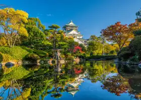
Osaka Castle Main Tower (Osaka Castle Museum)
7.4
4.6/51471 Reviews
From SGD 5.17
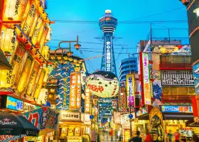
Tsutenkaku
7.2
4.5/5613 Reviews
From SGD 8.61
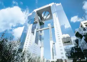
Umeda Sky Building
7.5
4.6/5818 Reviews
-SGD 0.07
From SGD 12.85
Nearby Attractions
Tenkawa Benzaiten-sha | Koyasan | Ryusenji Temple | Amanogawa Hot Spring | 天川薬湯センター みずはの湯 | Mount Yoshino | Oku-no-In | Kashihara Jingu | Kongobu-ji | Tanize Suspension Bridge | Mitarai Valley | Mount Ōmine | Nishinotani-fureainomori Campground | Tenkawamura Dorogawa Eco Museum | Hahago-do Shrine | Kongobu-ji Danjo Garan (Elevated Precinct) | Tanzan Jinja | Oka Temple | Asuka Ji | Tsubosaka-dera | Minamihiura Family Travel Village | Abe Monju-in | Daimon Gate | Road Station Yoshinoji Oyodo i Center | Fujiwara Palace Ruins | Kamokimi-no-yu Hot Spring | Ofusa Kannon Temple | Uda Animal Park | Yoshimizu Shrine | Asuka-no-Yu
Popular Types of Attractions in Tenkawa
Parks | City Parks | Botanical Gardens | Amusement Parks | Religious Sites | Other Places of Worship | Temples | Churches and Cathedrals | Exhibition Centers | Museums | Art Museums | Art Galleries | Architecture & Landmarks | Monuments | landmark | Featured Neighborhoods | Historic Sites | Historical Sites | Castles | Cemeteries | Lifestyle | Hot Springs | Entertainment Centers | Libraries | Popular Spots | Nature | Lakes | Attractions | Mountains | Outdoor Sports
Popular Restaurants in Tenkawa
Kiraku Kyube | Dorogawa Kawauo Center | Gorogorojaya | Kadojin | Ohashi Chaya | Kakisen | Nishigi | Kosuke | Kamekiyo | Shikisai Ueki | Otori | Cafe Wind | Kiraku Shokudo | Gorogorotei
Recommended Attractions at Popular Destinations
Bangkok attraction near me | Manila attraction near me | Tokyo attraction near me | Taipei attraction near me | Hong Kong attraction near me | Seoul attraction near me | Los Angeles attraction near me | Shanghai attraction near me | New York attraction near me | Kuala Lumpur attraction near me | Osaka attraction near me | Shenzhen attraction near me | London attraction near me | Singapore attraction near me | Guangzhou attraction near me | San Francisco attraction near me | Beijing attraction near me | Bali attraction near me | Macau attraction near me | Paris attraction near me | Jakarta attraction near me | Ho Chi Minh City attraction near me | Orlando attraction near me | Phuket attraction near me | Toronto attraction near me | Chicago attraction near me | Cebu attraction near me | Istanbul attraction near me | Seattle attraction near me | Dallas attraction near me
Popular Ranked Lists
Popular Premium Hotels in Wutai | Popular Family-friendly Attractions Near Yunlong | Top 15 Local Restaurants in Langkawi | Top 3 Premium Hotels in Saint Ann | Popular Premium Hotels in Damnoen Saduak | Popular Family-friendly Attractions Near Xiuning | Top 20 Local Restaurants in Istanbul | Popular Family-friendly Attractions Near Rong County | Popular Premium Hotels in Sohar | Popular Premium Hotels in Amoreira | Top 12 Local Restaurants in Phu Quoc Island | Popular Family-friendly Attractions Near Yongdeng | Popular Premium Hotels in Fushun | Popular Premium Hotels Near Finistere | Popular Luxury Hotels Near Sale | Popular Family-friendly Attractions Near Benxi | Popular Premium Hotels in Nyaung-U | Popular Premium Hotels in Pujiang | Popular Family-friendly Attractions Near Yi County | Popular Luxury Hotels Near Carcagente | Popular Premium Hotels in Mobile County | Popular Family-friendly Attractions Near Gaolan | Popular Family-friendly Attractions Near Luannan | Top 20 Local Restaurants in Hefei | Popular Premium Hotels in Province of Gorizia | Popular Premium Hotels in Bilgah | Popular Family-friendly Attractions Near Yifeng | Top 5 Bars in Adelaide | Top 13 Local Restaurants in Abu Dhabi
More Things To Do in Tenkawa
JR Haruka Express Train Ticket: Kansai Airport to Tennoji/Shin-Osaka/Osaka/Kyoto/Nara/Kobe (Instant Confirmation) | Osaka Limousine Bus Ticket : Kansai Airport - Osaka City / Universal Studios / Kyoto Airport | [Osaka Nankai Rapi:t Ticket (Kansai Airport - Osaka Namba/Shin-Imamiya/Tennoji) One-way e-ticket] | Japan eSIM | SoftBank/IIJmio Unlimited 4G High Speed data(Natural day) | JAPAN RAIL MINI PASS Kansai Area (3 Days | JR Pass) | JR Kansai Wide-Area 5-Day (immediate e-voucher issue) | Kyoto Kiyomizudera one-day tour[Nara Park/Kinkaku-ji Temple/Fushimi Inari Taisha Shrine/Arashiyama/Kimono Experience | Chinese/Mandarin Driver and Guide] | Osaka Subway/Bus Ticket(1day pass/2day pass) | 【 Free Osaka Subway Ticket】Kansai Attractions Transportation Pass|Have Fun In Kansai|Kansai Enjoyment Weekly Pass 1 Week Free Pass | Japan Arashiyama + Kinkakuji + Kiyomizudera Day Tour [Arashiyama Train Tickets+ Optional 13-person Small Group/Depart from Osaka and Kyoto] | Asia・Australia eSIM|AIS SIM2Fly 8 days 6GB High-speed Unlimited 5G/4G Data | Keihan Railway | Kyoto–Osaka Sightseeing Pass E-voucher (1-Day or 2-Day) & OSAKA Metro 1-Day Pass | JR PASS Kansai-Hokuriku Area Pass 7 Day / Hokuriku Area Pass 4 Day | Japan eSIM | SoftBank Unlimited 4G High Speed Data (1 day = 24 hours) | Private Full-Day Walking Tour of Kyoto | Private arrival Transfer from Kansai airport to Osaka city | Private Kobe Tour for Families with a Local, 100% Personalized | Full-Day Private Guided Tour in Kyoto, Arashiyama | Kyoto Evening Gion Food Tour Including Kaiseki Dinner | Kyoto, Japan Sanzen-in Temple Day Tour | Wakayama Castle + Kuroshio Market + Todaiji Temple + Nara Park 1-Day tour 【Depart from Osaka】 | Japan's Fushimi Inari Taisha Shrine + Arashiyama Sagano Sightseeing Train Tickets+ Kiyomizu Temple One-day Tour [Sakura Season Limited English Boutique Tour Departs from Osaka and Japan Chartered Chartered Vehicle] | Kyoto Late Bird tour | eSender - Japan eSIM daily package/data package (QR code) | eSender- Brunei/Indonesia/Singapore/Japan and many other countries and regions eSIM daily package/data package (QR code) | 10 Must-see Spots in Kyoto One Day Private Tour (up to 7 people) | Shared Arrival Transfer : Kansai International Airport to Kyoto City | ARASHIYAMA, KINKAKUJI, NARA Park Day Tour from Osaka | Osaka Walking Tour with a Licensed Guide
Payment Methods
Our Partners
Copyright © 2024 Trip.com Travel Singapore Pte. Ltd. All rights reserved
Site Operator: Trip.com Travel Singapore Pte. Ltd.
Site Operator: Trip.com Travel Singapore Pte. Ltd.
All around is the highest peak of the mountains, Kinki.
You can enjoy the 360 ° view, but there are only mountains around. It means that you are in that depth. The summit is not very large, so I think Miyama is better for a long break.
Ambience of shugendo
Overnight at Miyama Hut. I left my luggage and went back and forth. It's less than an hour. The dead trees created an atmosphere and there was just fog, so it was a quaint mountain trail. There are some rocky roads that are difficult to walk. The weather was bad and there was no view, but it's a fun way just to walk
Near the highest peak! Chiba から
H30 GW 5/2 I drove out Chiba at 7:30 pm and went on a high-speed via the National. I arrived at the west exit of the Gyojakan Tunnel at 5/3 7 am, and the parking lot was still stopped at less than half. This was my first time in the mountains of Kinki, and the weather was nice at first, but as I climbed, it rained in the clouds. The temperature was low and there was no view at the top of the mountain. When I came down on my way home, I could see the surrounding mountains 々.
Near the highest peak 1915m
I climbed during the autumn leaves. Perhaps because it was after the rain, there were places where the road leading from Mt. Miyama was muddy and some collapsed mountain trails. It was a pity that I couldn't see much scenery due to fog and light rain, but I felt a sense of accomplishment. Please note that the summit is narrow and windy. It seems that there is a place where cute flowers called Oyama Renge bloom around June, so I want to go again.
the west exit of the gyojakan tunnel is safe from the east side!
From Nagoya, follow the guide of the car navigation system and aim for the west exit of the Gyojakan Tunnel from the Kawai intersection of Amakawa Village. The west side of the tunnel is close to a terrible road. ○ The width that one car can finally pass, and when an oncoming car comes, move the car back and forth and give it up. ○ Prepare for vehicle damage due to falling stones. After descending the mountain, when I went out to the east side of the tunnel toward Odaigahara, I was relieved that it was on the national highway and the distance was long. If you are worried about driving, if you go from the main side of kamikitayama village to the west exit of the tunnel, the road width is wide, and the car is sliding ...