Fenshuiling Club
分水嶺A provincial person is not familiar with but locals especially like to go to the hot Internet celebrity reviews. It is very difficult to find a parking space on non-weekends. I heard from local friends that traffic jams began three kilometers away from the top of the mountain on weekends. Mainly from the perspective of national geography, ~ is more meaningful. Those who like geography must check in; due to the watershed altitude of more than 2100 meters, the top of the mountain is particularly comfortable, only more than 20 degrees; Self-driving ~ It takes 50 minutes to an hour from the foot of the mountain to the watershed. It is faster to go down the mountain but it takes 40 minutes. Otherwise, it will take more time (it is not recommended to go if the driving technology is not very good); it is recommended to bundle with Jingye Temple for just a while in the afternoon!
More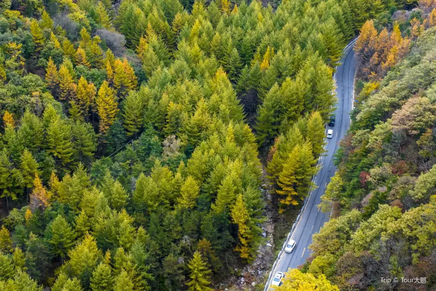
Recommendations Near Fenshuiling Club
Fenshuiling Club Reviews: Insider Insights and Visitor Experiences
Some reviews may have been translated by Google TranslateYou Might Also Like
Emperor Qinshihuang's Mausoleum Site Museum
Huaqing Pool

"The Song of Everlasting Sorrow"
Xi 'an City Wall
Nearby Attractions
Popular Types of Attractions in Xi'an
Popular Restaurants in Xi'an
Recommended Attractions at Popular Destinations
Popular Ranked Lists
Popular Trip Moments
Popular Travel Types
More Things To Do in Xi'an
Site Operator: Trip.com Travel Singapore Pte. Ltd.
A provincial person is not familiar with but locals especially like to go to the hot Internet celebrity reviews. It is very difficult to find a parking space on non-weekends. I heard from local friends that traffic jams began three kilometers away from the top of the mountain on weekends. Mainly from the perspective of national geography, ~ is more meaningful. Those who like geography must check in; due to the watershed altitude of more than 2100 meters, the top of the mountain is particularly comfortable, only more than 20 degrees; Self-driving ~ It takes 50 minutes to an hour from the foot of the mountain to the watershed. It is faster to go down the mountain but it takes 40 minutes. Otherwise, it will take more time (it is not recommended to go if the driving technology is not very good); it is recommended to bundle with Jingye Temple for just a while in the afternoon!
Watershed, as the name implies, divided the waters, the watershed south for the Yangtze River waters, north for the Yellow River waters. From the north slope of Qinling Mountain to the mountain top along the mountain road, along the G210 National Highway up about 33 kilometers through the highest point of Qinling Highway, located at 997 kilometers of National Highway G210, 65 kilometers from Xi'an city center, of which about 28 kilometers are all uphill sections, the altitude is 2100 meters. The temperature, climate and topography of the Qinling Mountains all showed different changes, and the Qinling-Huaihe line became the most important north-south dividing line in China's geography.