
Things to do in Absheron
Explore top experiences
Top 10 attractions in Absheron


Gobustan Rock Art Cultural Landscape
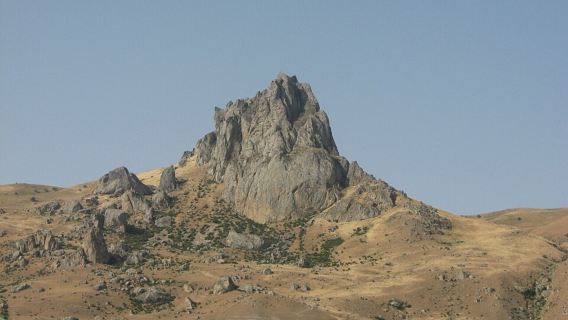
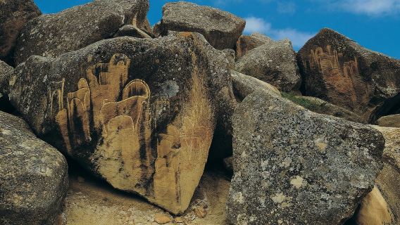
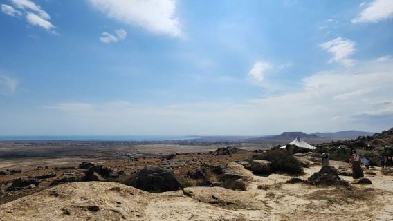
Gobustan Rock Art Cultural Landscape is located in the semi-desert hills southwest of Baku and is an open-air site famous for its prehistoric rock carvings. The petroglyphs are concentrated on three exposed rocky hills, including Boyukdash and Kichikdash. Dating from the Upper Paleolithic tens of thousands of years ago to the Middle Ages, themes such as hunting, bullfighting, group dancing, camel caravans, and the sun and stars are superimposed on the rock surfaces. The carvings of reed boats with rows of rowers are particularly striking, resembling later Nordic longships. Scattered among the rocky hills are caves, settlements, and burial sites once inhabited by ancient people; the cave known as "Seven Beauties" features paintings of women participating in hunting. The "Gaval Dash" (tambourine stone) at the entrance is a long stone slab that produces a crisp sound similar to a tambourine when struck with a small stone, serving as a natural percussion instrument left by ancient people. The Latin inscription at the foot of Boyukdash Mountain, created by a Roman legion centurion in the 1st century AD, is a rare piece of evidence of Roman presence reaching the shores of the Caspian Sea. A petroglyph museum is located next to the entrance, using unearthed artifacts and video materials to recreate scenes of prehistoric life. You can visit the exhibition first before heading up the mountain to explore the rock carvings.Baku · 29.3 km from Absheron

Old City Baku
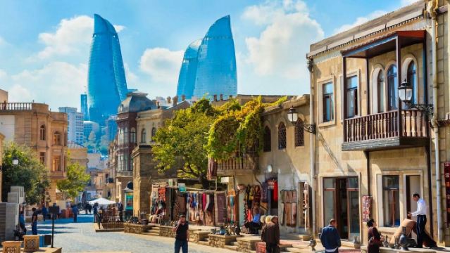
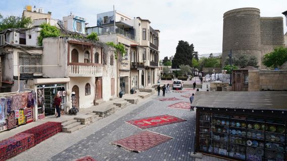
Old City Baku is the historic core of Baku, enclosed by ancient city walls. Its history is generally believed to date back at least to the 12th century, though some scholars suggest its origins can be traced as far back as the 7th century. The Old City is adjacent to the Caspian Sea, with cobblestone streets winding along the slopes. Local families still live deep within the alleys, where old buildings, workshops, and residences stand side by side. Walking through them, you can both sense the weight of the historical sites and encounter the vibrant local life of Baku. The charm of the Old City is also hidden in its small alleys. In the Middle Ages, it was a frequent stop for caravans. The Multani Caravanserai and Bukhara Caravanserai, which hosted merchants from India and Central Asia, still stand today. The alleys are lined with carpet workshops, handicraft shops, and souvenir stalls, as well as many traditional restaurants serving local dishes like pilaf and kebabs.Baku · 47.3 km from Absheron

Flame Towers
The Flame Tower is composed of three towers and is the tallest building in Baku. It is named after its appearance that resembles a flame. The project, designed by the American architecture firm HOK, is currently used as a luxury residential apartment, an office building and a hotel (Fairmont Baku Flame Towers Hotel and Resort). These three huge "tongues of fire" can be seen in almost any corner of Baku (it is recommended to watch on the coast of Baku), and they are very conspicuous. Whenever night falls, the tower body, which completely covers the LED screen, will show a variety of effects, just like a beating flame, showing the vigorous vitality of modern Baku.Baku · 46.8 km from Absheron

Palace of the Shirvanshahs
Palace of the Shirvanshahs is located on a high hill in Old City Baku and is a palace complex left behind by the Shirvanshah dynasty of Azerbaijan. Most of the main buildings were completed in the 15th century, and the Murad Gate was added to the east side in the 16th century. The entire complex is built of light-colored limestone and is divided into two courtyards based on the terrain. The council hall, royal mausoleum, mosque, bathhouse, and reservoir are laid out in sequence within the same enclosed space, incorporating residential, administrative, religious, and funerary functions. The main structure is a two-story stone building, with dozens of rooms connected by several narrow spiral stone staircases. You can enter the octagonal domed hall through an intricately carved gate. In the center of the council hall courtyard stands an octagonal pavilion surrounded by pointed-arch arcades, with exquisite stone carvings on the lintels. The lower courtyard contains the royal mausoleum and a mosque with a minaret, as well as the octagonal mausoleum of the court Sufi scholar Seyid Yahya Bakuvi, commonly known as the Dervish Mausoleum. Further down are the remains of the bathhouse, which is half-buried underground with only its domes visible, and the underground reservoir. Today, it has been converted into a museum, displaying archaeological finds such as coins, copperware, weapons, musical instruments, and carpets, as well as a restored model of the Old City's layout. When visiting, be sure to pay attention to the stone-carved lintels at the entrances of each building, as clues about their dates and purposes are mostly hidden there. Looking back from the upper courtyard platform, you can also overlook the layered rooftops of the Old City.Baku · 47.4 km from Absheron

Sheki Khan's Palace
Sheki Khan's Palace is tucked away in the fortress courtyard on the high ground in the northeast of the old city of Sheki, and was once the summer palace of the Sheki Khan. This two-story building, along with the pool and old plane trees in the courtyard, has been preserved and later converted into a museum. It is not large in size, over 30m long and less than 10m wide. The layout of the upper and lower floors is the same, with three rooms lined up in a row, connected by a south-facing open corridor. The first floor was where the Khan received guests and handled affairs, while the second floor was for the family's living and entertaining. The outer walls are decorated with geometric patterns made of dark blue, turquoise, and ochre tiles. The interior walls are covered with murals, featuring patterns of flowers in vases and plants, and in the halls upstairs, you can also see entire scenes of hunting and warfare. A distinctive attraction here is the stained glass window called Shebeke, where thousands of pieces of colored glass are embedded into fine wooden grids. The entire structure uses no glue or nails, relying entirely on interlocking wood pieces, creating a display of shimmering light when sunlight passes through.Azerbaijan · Sheki City

Maiden Tower
Maiden Tower is located at the southeast corner of Old City Baku, adjacent to the Caspian Sea. It is a cylindrical stone tower built around the 12th century, with eight floors inside and stone walls at the base several m thick. It is featured on the 10-manat banknote and is considered one of the symbols of Azerbaijan. It has now been converted into a museum, with exhibits detailing the urban evolution of Baku from ancient times to the present. The second floor also houses an ancient well, which research suggests was used to collect rainwater. Despite being right next to the sea, the water is fresh. You can climb to the top along the spiral stone staircase built into the wall to overlook the stone alleys and minarets of the Old City, and gaze out at the expansive waters of Baku Bay and the seaside boulevard. The lighting is particularly good in the evening. After dark, the tower lights up, making it a highly recognizable feature of the Old City's nightscape.Baku · 47.7 km from Absheron

Baku Boulevard
Baku Boulevard features numerous sightseeing and entertainment facilities, including amusement parks, yacht clubs, musical fountains, and various statues and monuments, making it a favorite among locals and tourists. 2009 marked the 100th anniversary of the establishment of Baku Boulevard. As a key scenic area in Baku, Baku Boulevard also frequently hosts various gatherings, performances, celebrations, ceremonies, parades, and more, and has been the designated venue for Baku's New Year's Eve celebrations in recent years.Baku · 48.3 km from Absheron

Atashgah Zoroastrian Fire Temple
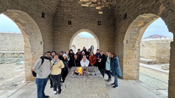
Ateshgah, in Persian, means "fire place", that is, the place where there is the holy fire and the place where the holy fire is sacrificed. The Baku area is rich in oil and natural gas. When many natural gas encounters open fires, they form eternal flames. In ancient times, these eternal flames were considered miracles, and they became the holy place of Hindu Shiva sect in those days. The original Eternal Fire was extinguished in the 19th century due to the exhaustion of resources. Now what tourists see is the artificial reconnection in the Soviet period, so on the ground in the fire temple, you can see obvious natural gas pipelines. The public transportation here is not very developed, and tourists usually go here by chartered car. There are some houses next to the Fire Temple, and there are some convenient displays of local culture and history.Baku · 62.6 km from Absheron

Highland Park
Highland Park attracts many tourists with its spectacular panoramic view and rich cultural connotations. Located at the highest point of the city, Highland Park overlooks the Bay of Baku and the Caspian Sea, providing a good viewing position and an ideal place to enjoy the city skyline and sunset. The park is lined with trees and winding trails, making it a great place for citizens and tourists to take a leisurely stroll. Strolling along the paths of the park, visitors can enjoy the tranquil natural environment while appreciating the bustling scene of downtown Baku. There are multiple observation decks in the park, each of which provides a different angle of city views, especially at night, when the city lights are lit up, the view is even more charming. In addition, there are the well-known Flame Towers near the park. These three modern skyscrapers have become Baku's iconic buildings with their unique design and nighttime light shows. Visitors can enjoy the full view of the Flame Towers from the heights of the park and feel the ingenious fusion of modern architecture and natural landscapes.Baku · 47.1 km from Absheron

Diri Baba Mausoleum
DiriBaba is located on a rock in the village of Ma'aze. It is said that visiting DiriBaba can cure diseases and reduce disasters. The mausoleum building is a masterpiece of the Shirvan school of architecture and a magnificent creation of the art of the Old Masters.Qobustan · 33.8 km from Absheron
Experiences you can't miss in Absheron
Featured Cultural experiences in Absheron
View all Cultural experiences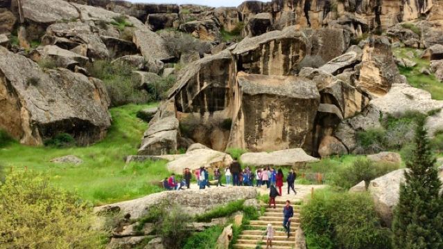
Free cancellation
Book now for tomorrow
FromMYR 191.34
4.7/5
· 28 reviewsFree cancellation
Book now for today
5% off
Limited-time sale
FromMYR 111.70MYR 117.58
Free cancellation
Book now for tomorrow
FromMYR 216.03

Free cancellation
Book now for today
20% off
Limited-time sale
FromMYR 29.28MYR 36.6
Free cancellation
Book now for tomorrow
FromMYR 216.03
5.0/5
· 99 reviewsFree cancellation
Book now for today
99 consecutive positive reviews
5% off
Limited-time sale
FromMYR 104.69MYR 110.21
5.0/5
· 5 reviewsFree cancellation
Book now for today
5% off
Limited-time sale
FromMYR 128.93MYR 135.72
Free cancellation
Book now for today
5% off
Limited-time sale
FromMYR 98.95MYR 104.16
Featured Day tours in Absheron
View all Day tours
5.0/5
· 3 reviewsFree cancellation
Instant confirmation
Book now for tomorrow
FromMYR 498.72
3.5/5
· 2 reviews· 41 bookedFree cancellation
Instant confirmation
Book now for tomorrow
FromMYR 108.82
Free cancellation
Instant confirmation
Book now for tomorrow
FromMYR 122.42
4.8/5
· 76 reviewsFree cancellation
Book now for today
25 consecutive positive reviews
5% off
Limited-time sale
FromMYR 108.56MYR 114.28
4.9/5
· 84 reviewsFree cancellation
Book now for today
97.6% of travelers recommend
5% off
Limited-time sale
FromMYR 4.36MYR 4.59
Featured Food & drink in Absheron
View all Food & drink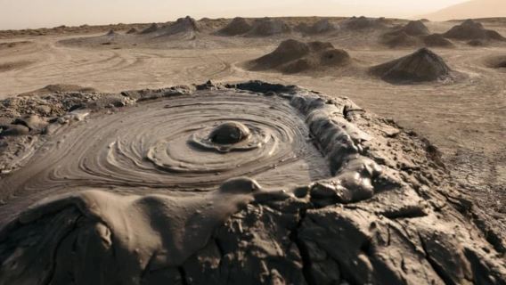
Free cancellation
Book now for tomorrow
5% off
Limited-time sale
FromMYR 89.20MYR 93.9
4.8/5
· 876 reviewsFree cancellation
Book now for today
96.8% of travelers recommend
5% off
Limited-time sale
FromMYR 92.12MYR 96.97

4.9/5
· 13 reviewsFree cancellation
Book now for today
5% off
Limited-time sale
FromMYR 88.20MYR 92.85
5.0/5
· 2 reviewsFree cancellation
Book now for today
5% off
Limited-time sale
FromMYR 112.44MYR 118.36

5.0/5
· 1 reviewFree cancellation
Instant confirmation
Book now for today
FromMYR 149.62
4.9/5
· 56 reviewsFree cancellation
Book now for tomorrow
98.2% of travelers recommend
5% off
Limited-time sale
FromMYR 96.90MYR 102.01
4.7/5
· 122 reviewsFree cancellation
Book now for tomorrow
91% of travelers recommend
FromMYR 224.43
Featured Outdoor experiences in Absheron
View all Outdoor experiences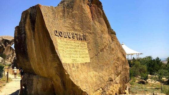
Free cancellation
Book now for today
5% off
Limited-time sale
FromMYR 19.40MYR 20.43
4.9/5
· 61 reviewsFree cancellation
Book now for today
96.7% of travelers recommend
5% off
Limited-time sale
FromMYR 38.77MYR 40.82
Free cancellation
Book now for tomorrow
5% off
Limited-time sale
FromMYR 29.07MYR 30.6
4.7/5
· 3 reviewsFree cancellation
Book now for today
5% off
Limited-time sale
FromMYR 24.41MYR 25.7
Free things to do in Absheron
Gobustan Rock Art Cultural Landscape
Baku · 29.3 km from AbsheronOld City Baku
Baku · 47.3 km from AbsheronFlame Towers
Baku · 46.8 km from AbsheronImmediate access, Book now for todayPalace of the Shirvanshahs
Baku · 47.4 km from AbsheronSheki Khan's Palace
Azerbaijan · Sheki CityMaiden Tower
Baku · 47.7 km from AbsheronBaku Boulevard
Baku · 48.3 km from AbsheronAtashgah Zoroastrian Fire Temple
Baku · 62.6 km from AbsheronHighland Park
Baku · 47.1 km from AbsheronDiri Baba Mausoleum
Qobustan · 33.8 km from Absheron
More ways to travel from Absheron
What travellers say about Absheron

水漫三楼July 12, 2026
5.0
The Gobustan Rock Art and Cultural Landscape, located on the western side of Khobstan, Azerbaijan, about 40 miles from the capital Baku, comprises three rock plateaus, with a core area of 537 hectares. The landscape preserves over 6,000 rock paintings dating from 5,000 to 20,000 years ago, depicting scenes of prehistoric human activity, animals, warfare, and religious dances. The area also contains Paleolithic to medieval settlement sites and burial remains, showcasing the trajectory of human settlement from the Wet Period to the Middle Ages. This region was part of the Shamaki District from 1930 to 1943 and from 1960 to 1990, and was renamed to its current name upon restoration in 1990. In 1966, the area was designated the Gobustan National Reserve and a National Historic Landscape of Azerbaijan, with the aim of protecting its natural and cultural heritage, including ancient sculptures and mud volcanoes. In 2007, it was inscribed on the World Heritage List according to cultural heritage criteria, its rock carvings documenting the connection between hunter-gatherer civilizations and the ancient Wet Period environment. Located between the Buyukdash, Kichikdash, and Jingirdagh mountains, this protected area is part of the larger Gobustan Protected Area, with a buffer zone of 3,096.34 hectares. The heritage site contains the easternmost known Roman soldier stone inscription and musical stones that produce sounds similar to hand drums. A museum at the entrance showcases the region's history through audiovisual materials and replicas of rock paintings.
Gobustan Rock Art Cultural Landscape

Ekaterina SolovevaMarch 11, 2025
5.0
Tips:Reasons to Recommend:Baku is a unique city that combines rich history and modernity. Here is an example of a three-day Baku vacation plan:-- Day 1: Historical Center and Old TownMorning:1. Icheri Sheher (Old Town)Start your day with a walk around the Old Town. Visit the Palace of the Shirvanshahs and the Minaret of the Miniature Mosque. Walk along the narrow streets and look at the ancient buildings.2. Breakfast CafeEnjoy breakfast at one of the cafes with local cuisine. Try pita or dolma.Afternoon:3. M
Old City Baku

翟海勇周雯瑾March 21, 2020
5.0
The Flame Hotel is a classic building in Baku! It is very beautiful and majestic! Also known as the Flame Towers. You can overlook the Caspian Sea! The hotel is a five-star hotel, more modern and with newer facilities than the Four Seasons Hotel.
Flame Towers

Karen晓喵February 12, 2020
5.0
Located at the highest point of the old city of Baku, the Shirvanshah Palace was built in the 15th century and is a shining pearl in the history of Azerbaijan architecture. The main entrance of the palace is decorated with a gatehouse and is located on the west side of the palace. The stairs of the gatehouse lead to the high octagonal hall with a dome. In 2000, the Shirvanshah Palace was listed as a World Cultural Heritage along with the old city of Baku.
Palace of the Shirvanshahs

LikeGorFebruary 6, 2020
5.0
This is also a worthwhile tourist attraction in Azerbaijan. The air is fresh and the environment is pleasant. There are exquisite buildings and magnificent murals, which is one of the highlights of this trip.
Sheki Khan's Palace

zinnia_615November 29, 2024
4.0
One of the oldest buildings in the old city, it is adjacent to the Caspian Sea coast. It has 8 floors and each floor window has defense facilities. It is also one of Azerbaijan's national business cards. Bending your waist and hunching your back, walking on the high and low steps, you may bump your head if you are not careful [covering your face J The city walk in the old city of Baku
can consume enough calories
Maiden Tower


_We***36October 31, 2019
5.0
Baku an unforgetable city very beautifull city and delicious food. must try the tea and walnuts jams yummy
Atashgah Zoroastrian Fire Temple

卡斯别克的雪花June 20, 2023
4.0
Standing on the top of the city and looking out to the Caspian Sea in the distance, the attractions on the mountain are also worth seeing. There are cars that can take you up, but I personally think it’s better to go up and see it! The whole city is in sight, and the three flame towers are right beside you.
Highland Park
