OverviewBookNearbyReviewsWin Prizes
Share to
Daedong River (Taedong River)
2.3
26 Reviews
 based on 44 reviews
Recommended sightseeing time:1 hour
Address:
PyongyangMap
What travelers say:
Looking down at the buildings on both sides of the Datong River Scenic Area, it is also very beautiful and beautiful, the scenery is good, the scenery is pleasant, the fun is strong, the choice is good, the feeling is also very good, the mood is also good, a good place for taking pictures.
More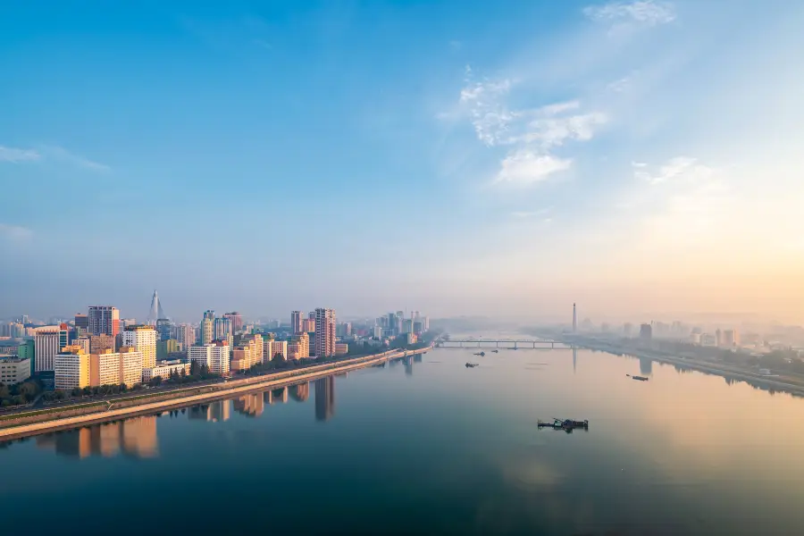
See 1 photo
Daedong River (Taedong River) Highlights: Must-See Features and Attractions
Some information may have been translated by Google Translate
The Datong River flows through the urban area, with a total length of 450.3 kilometers and a drainage area of 20,247 square kilometers. It is one of the five major rivers in North Korea. The water of Datong River is as clear as jade, so it is also known as "clear stream" and "jade stream". On both sides of the strait, there are Kim Il-sung Square, Juche Thought Tower, Datongmen, Lianguang Pavilion, etc. Lingluo Island, Yangjiao Island, and Ai Island on the Datong River are all amusement parks.
Recommendations Near Daedong River (Taedong River)
Daedong River (Taedong River) Reviews: Insider Insights and Visitor Experiences
Some reviews may have been translated by Google TranslateWrite a Review
 (26 Reviews)Trip.com
 (44 Reviews)TripAdvisor
/5
Excellent ReviewsAll (26)
Latest
With Photos (12)
Positive Reviews (23)
- 1
- 2
- 3
- 4
- 6
Nearby Attractions
Pyongyang Metro | Pyongyang | Kim Il Sung Square | Sino-Korean Friendship Tower | Arch of Triumph | Juche Tower | Pyongyang Station | Former Residence of Mangyongdae | Koguryo Tombs | USS Pueblo | Fatherland Liberation War Victory Museum | Mansudae Hill Grand Monument | Mangyongdae Children's Palace | Mansudae Fountain Park | Munsu Water Park | East Pyongyang Grand Theater | Kim Il-sung Stadium | Geumsusan Memorial Palace | Workers' Party Foundation Monument | Chollima Statue | Bennett Valley | The State Circus | Yanggakdo Stadium | Taesongsan | Former Residence of Mangyongdae | Rungnado | Mansudae Hill | Arch of Reunification | Turu-sŏm | Pyongyang
Popular Types of Attractions in Pyongyang
Popular Restaurants in Pyongyang
Recommended Attractions at Popular Destinations
Bangkok attraction near me | Manila attraction near me | Tokyo attraction near me | Hong Kong attraction near me | Seoul attraction near me | Taipei attraction near me | Los Angeles attraction near me | New York attraction near me | Shanghai attraction near me | Kuala Lumpur attraction near me | Shenzhen attraction near me | Osaka attraction near me | London attraction near me | Singapore attraction near me | Guangzhou attraction near me | San Francisco attraction near me | Beijing attraction near me | Macau attraction near me | Bali attraction near me | Paris attraction near me | Ho Chi Minh City attraction near me | Jakarta attraction near me | Orlando attraction near me | Phuket attraction near me | Chicago attraction near me | Toronto attraction near me | Istanbul attraction near me | Cebu attraction near me | Seattle attraction near me | Dallas attraction near me
Popular Ranked Lists
Popular Premium Hotels Near Taney County | Popular Premium Hotels in Rybnik | Popular Family-friendly Attractions Near Dong'e | Popular Luxury Hotels Near Soderakra | Popular Family-friendly Attractions Near Jingyang | Popular Family-friendly Attractions Near Beichuan | Popular Family-friendly Attractions Near Sinan | Popular Family-friendly Attractions Near Guantao | Popular Family-friendly Attractions Near Guannan | Popular Premium Hotels in Daman | Top 4 Bars in Kanazawa | Popular Premium Hotels Near Columbia-Shuswap B | Popular Premium Hotels Near Tangolunda | Popular Luxury Hotels Near Oshima District | Top 11 Fine Dining in Hanoi | Popular Family-friendly Attractions Near Xianfeng | Popular Family-friendly Attractions Near Anxi | Top 6 Fine Dining in Taiyuan | Popular Luxury Hotels Near Gouveia | Popular Family-friendly Attractions Near Jincheng | Popular Family-friendly Attractions Near Fuping | Top 10 Bars in Amman | Popular Luxury Hotels Near Medio Cudeyo | Popular Family-friendly Attractions Near Xinghua | Popular Family-friendly Attractions Near Mengla | Popular Luxury Hotels Near Blunsdon St. Andrew | Top 6 Luxury Hotels in Suzhou | Top 20 Fine Dining in Munich | Popular Family-friendly Attractions Near Langfang
Popular Travel Types
Payment Methods
Our Partners
Copyright © 2024 Trip.com Travel Singapore Pte. Ltd. All rights reserved
Site Operator: Trip.com Travel Singapore Pte. Ltd.
Site Operator: Trip.com Travel Singapore Pte. Ltd.
Looking down at the buildings on both sides of the Datong River Scenic Area, it is also very beautiful and beautiful, the scenery is good, the scenery is pleasant, the fun is strong, the choice is good, the feeling is also very good, the mood is also good, a good place for taking pictures.
Datong River Scenic Area is also very important mother river, in North Korea a large river across many rivers and an important river of the city, this river is also very clear, Datong River Scenic Area is still a good place for transportation, you can rent a boat to visit.
Datong River is the fifth largest river in North Korea, originating from the Wolf Forest Mountains between Daxing County and Changjin County, South Hamgyong Road, and flowing through Nanpu City into the West Sea of North Korea. This river has several sluices such as West Sea Sluice built on it, forming a large artificial lake with no dry seasons. The Datong River adds to Pyongyang's beautiful scenery. The last few are offering foreign tourists on cruise ships.
Datong River is one of the geographical indications of North Korea. It is located in the northwest of the Korean Peninsula and is the fifth largest river in North Korea. It is450.3 kilometers long and has a basin area of 20,000 square kilometers. It is conducive to shipping due to the depth of the river bed and the impact of the Yellow Sea tide. It originated from Cijiang Road in the Wolf Forest Mountains, and passed through Pyongyang City and then poured south into the North Korean Gulf in Nanpu City. In ancient China, it was called Lishui, and it became a boundary river between China and North Korea for a long time. The Datong River originated from the southeast slope of Langlin Mountain, South Xianjing Road, North Korea, at an altitude of 2184m, from the north east to the southwest, and successively flowed through Ping An South Road and Pyongyang City, and entered the West Korean Bay in Nanpu, and finally injected the Yellow Sea. There are sluices such as Western sea sluices on the river, forming an artificial lake with no dry seasons. Datong River adds beautiful scenery to Pyongyang. Pyongyang has famous eight scenes such as "Bmi to enjoy the spring" and "Floating Bi to play the moon". I will definitely go and see it if I have a chance.
Take the "Datong River" cruise at night to see the night view of Pyongyang. The cruise ship setting is still very luxurious, dinner is eaten on the boat, and there are good quality performances! It’s just that the distance between the flight is too short, and the night view is also...